Guilin’s Karst Peaks and the Landscape on China’s Currency
Guilin’s karst peaks are among the most recognisable landscapes in China, rising above the Li River in a formation that has shaped Chinese painting, poetry and national identity for centuries.
Nine centuries of Chinese painters came to Guilin and tried to capture the way these limestone towers appear above the river at dawn. The isolated peak rising from mist, reflected in still water below, became one of the defining images of Chinese landscape art. Yet the real landscape keeps escaping the frame. The mist moves, the light shifts and the river changes the scene from one moment to the next.
Guilin is not only a landscape to admire from a distance. Elephant Trunk Hill, Reed Flute Cave and the Li River place travellers inside the geography behind the image. The ten-day route through Beijing, Xi’an, Guangxi and Shanghai, with this landscape as its centrepiece, is mapped in the China’s Riverlands guide.

The
Science and the Shape
The rain did this. Sixty-five million years of it, barely acidic, working through limestone with a patience that has no human equivalent.
Two Types of
Karst
Guilin's landscape contains two distinct forms of karst topography, and the difference between them changes what you see depending on where you stand.
Two types of karst landscape predominate in Guilin: fenglin, or peak forest, where isolated towers rise from flat ground, and fengcong, or peak cluster, where towers share a linked base. The fenglin type, with isolated towers rising from the valley floor, is what produces the landscape most closely associated with the Guilin karst peaks internationally: the one on the banknote, the one in the paintings. The fengcong type, where the peaks are connected at their bases and cluster into groups, produces a denser, more complex visual field that reads differently from the river.
The monsoon climate is the specific driver of Guilin's karst intensity. High rainfall during the warmest season accelerates acid dissolution by increasing the volume of water moving through the limestone. Other karst regions in the world receive less rainfall, less consistently, and their landscapes reflect this in the slower pace of their erosion. Guilin's peaks are as dramatic as they are because the rain here has been so regular, for so long, and in such quantities.
When the tectonic plate carrying India collided with the Asian plate to create the Himalayas, the impact raised Guilin from the seabed. The peaks that now rise 200 metres above the Li River valley were once 200 metres below sea level. The ichthyosaurs that swam through this limestone when it was still an ocean floor are present in the fossil record preserved by the cave systems underground. The landscape holds its entire geological autobiography.

What the
Dissolution Left Behind
The acid moves along fracture lines first. Where the fractures were close together, dissolution was faster and the rock between them disappeared relatively quickly. Where the limestone was pure and unfractured, it resisted longer. The towers that remain today are the sections of the original limestone bed where the rock was purest, most coherent and least fractured.
This is why the Guilin landscape looks the way it does rather than the way a mountain range looks. A mountain range is accumulative, built up by tectonic pressure. China's karst landscape is subtractive, defined by geological removal. The visual result is inverted relative to most landscapes: the empty space is where the geological action occurred; the solid towers are where it did not.
Understanding this inversion changes the experience of standing in a boat watching the peaks drift past. You are not watching mountains rise. You are watching the edges of what rain left behind.

The
Peaks and Their Histories
Each formation in Guilin has a name, a documented history, and centuries of visitors who left their observations in ink on stone.
Elephant Trunk
Hill
At the confluence of the Li River and the Peach Blossom River, Elephant Trunk Hill has been Guilin's defining landmark since the Tang Dynasty. A natural arch at water level, eroded completely through the base of the tower, creates the illusion of an elephant drinking. The arch is not architectural. It is the result of the same dissolution process that formed the surrounding landscape: water moving through a fracture line until the fracture became a passage and the passage became a window.
The origins of the formation lie deep in geological time. When tectonic activity raised Guilin from the seabed, the limestone that had accumulated beneath a shallow tropical sea was exposed to millions of years of weathering and erosion. Over time, these forces shaped the distinctive karst landscape for which Guilin is known today, with Elephant Trunk Hill becoming its most recognisable example.
The arch frames its own reflection in the river below. At the right hour, in still water, the arch and its mirror image form a complete circle on the surface. Tang Dynasty poets described this as a moon on the water. They were being geometrically accurate. The formation has been depicted in Chinese painting and poetry for more than 1,200 years, and it appears in stele inscriptions along the hill's base from multiple dynasties.
Inside the hill, the Moon Over Water Cave holds inscriptions carved by visitors across centuries of documented tourism. The earliest recorded visits date to the Tang Dynasty. Elephant Trunk Hill is one of the longest continuously visited natural landmarks in China.

Solitary
Beauty Peak
Duxiu Peak rises 152 metres from within what was once the Jingjiang Prince's Palace complex during the Ming Dynasty. The steepest of Guilin's urban karst towers, its cliff face contains 306 stone steps carved directly into the rock. The palace complex surrounding its base, built by Prince Zhu Shouqian in 1372, is the best-preserved Ming imperial palace complex outside Beijing. For centuries it served as the administrative centre of Guangxi. Today it forms part of Guangxi Normal University.
The summit provides the finest elevated view of Guilin's karst landscape within the city limits: towers rising from the surrounding urban fabric in every direction, the Li River visible as a thread of green to the south, and the countryside emerging beyond the city's edges. It is the ideal vantage point from which to understand Guilin as a city that adapted to its geological setting rather than attempting to reshape it.
The calligraphy inscription carved into the cliff face below the summit reads, "Guilin's landscape surpasses all under heaven." The phrase has been on this rock since the Song Dynasty. The claim was not modest. It has also not been seriously disputed.

The
Painting Tradition
The question of which came first, the landscape or the tradition it produced, has a clear answer here.
A Landscape
That Invented a Visual Language
The first artist to paint the Guilin landscape is held to be Mi Fu, who lived from 1051 to 1107 and is sometimes called the father of Chinese impressionism. Mi Fu used different ink shades and large dots applied with a flat brush to render slowly flowing landscapes of rivers and clouds.
The argument that Guilin's karst peaks are responsible for a significant part of what the world understands as the visual language of Chinese landscape painting is not hyperbolic. The shanshui tradition, mountains and water, that defines the ink-wash genre reached its formal peak during the Song Dynasty, precisely when Mi Fu was painting these peaks. The isolated tower rising from mist above a river, reflected below, with minimal foreground: this is a compositional structure that the Guilin landscape provided and that painters systematised into a tradition.
When former US President Bill Clinton visited Guilin, he observed that nowhere is like Guilin and that it reminded him of traditional Chinese paintings. His remark reflects the extent to which ideas of Chinese landscape beauty are shaped by the ancient aesthetics of shanshui painting, which has its roots in the fifth century.
Clinton's observation captures something real: the traditional Chinese landscape painting that many Western travellers recognise, with isolated mountains, misty water and vertical composition, looks like Guilin because Guilin is where the painters were looking. The landscape came first. The tradition followed.
The Guilin landscape has been reproduced in ink wash for nine hundred years. It appears in the conference rooms of the Chinese Embassy in Washington DC, in the lobby art of government buildings, and in the UN offices that house China's diplomatic presence. The 20 RMB banknote selection was the formalisation of something that had already been true for centuries: this landscape is part of China's visual identity, in the same way that the Eiffel Tower is part of Paris's.

Reed
Flute Cave: The Landscape Underground
Five kilometres northwest of Guilin's city centre, Reed Flute Cave is a 240-metre limestone cave system whose formation predates the Guilin karst peaks by 115 million years. Where the surface peaks were formed by rainfall dissolving the limestone from above, the cave was formed by underground water dissolving it from within.
The cave takes its name from the reeds that grew at its entrance and were traditionally crafted into flutes. The reed beds are still there. The flute-making tradition ended. The cave has been visited without interruption since the Tang Dynasty.
The cave walls preserve 77 inscriptions and poems carved between 792 AD, in the Tang Zhenyuan era, and the Song Dynasty. The oldest inscription, dating to 792 AD, makes this one of China's earliest documented tourist attractions.
Those inscriptions are not graffiti. They are literary compositions, written by scholars who came to this cave specifically for the aesthetic experience of its formations. The texts include poems, essays, and records of visits by groups of monks, the latter now studied as evidence of how Buddhism spread through Guilin's scholarly community during the Tang Dynasty. The cave was already a destination for educated visitors twelve hundred years ago. It holds the title of State Guest Cave, having welcomed numerous Chinese leaders and international dignitaries.
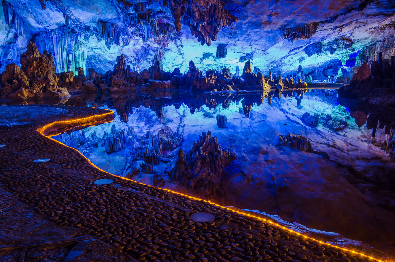
The Formations
The Crystal Palace chamber within the cave covers approximately 3,000 square metres and is large enough to accommodate 1,000 people. The stalactites and stalagmites that fill it have been accumulating at approximately one centimetre per century. The formations currently visible in this chamber require between 10,000 and 180,000 years to explain. They are still growing.
The specific shapes the formations have been given, Pines in the Snow, Mushroom Hill, Dragon Pagoda, Virgin Forest, are Chinese scholarly names applied by Tang Dynasty visitors and retained in the official nomenclature of the cave today. The imaginative tradition that named these shapes is as old as the inscription tradition that documented the visits. Both are evidence of the same thing: this cave has been understood as a place of aesthetic and intellectual significance for more than twelve centuries.
The karst process that formed Reed Flute Cave is also happening beneath Guilin's streets and under the Li River's bed. The city stands above a network of underground rivers and dissolved chambers that the surface landscape does not reveal. What is visible above ground is the skin of a geological system that extends considerably deeper.

Why
the Painters Were Not Stylising
The Tang Dynasty poet Han Yu described the Li River as a blue silk ribbon with emerald hairpins for mountains. The image has been quoted so many times that it risks becoming decorative. It should be taken literally.
Standing on the Li River between Yangdi and Xingping, where the peaks are most concentrated and the water's clarity is at its highest, the reflection of the karst towers is so precise that the boundary between stone and reflected stone becomes difficult to locate. The peaks above and the peaks below occupy the same visual register simultaneously. The river is the canvas, the karst is the ink, and the result is a composition that painters have been trying to reproduce for nine centuries without quite succeeding. The light changes. The mist changes. The water level changes. The real thing continues to outperform every attempt to stabilise it.
China's karst landscape is at its most concentrated along the 83-kilometre Li River route between Guilin and Yangshuo. Seeing the peaks from the water creates a different relationship than seeing them from within the city. The boat provides the distance that makes the full composition legible, and the river provides the reflection that doubles every tower's presence. That experience, four and a half hours of sustained revelation along China's most celebrated river journey, is what the Li River cruise through Guilin and Yangshuo exists to deliver.
What the terraces of Longsheng offer is a counterpart in human time. Where the karst peaks record what geology built across 65 million years, the Longji Rice Terraces record what the Zhuang and Yao communities built across more than 650 years, carving the same kind of patient, layered landscape into a mountain using tools rather than acid. Both are in Guangxi. Both belong to this route.

Guilin
in the Morning
The Guilin karst peaks are not a backdrop. They are the city's reason for existing, the reason the Li River follows the course it follows, the reason the painters came, and the reason the banknote committee made its decision. Everything in Guilin is in conversation with the limestone towers that rise from its streets and riverbanks, and the most honest way to spend a morning here is to follow that conversation rather than treat the city as a transit point before the cruise.
Elephant Trunk Hill before the tour groups arrive. The 306 steps of Solitary Beauty Peak in the early morning light. Reed Flute Cave before the afternoon rush, when the Tang Dynasty inscriptions on its walls are visible in the quieter chambers without a crowd in the frame. This is the Guilin that belongs to travellers who arrange their visit around what the city actually offers, rather than what it is most commonly known to provide.
The route that makes these two days in Guilin the beginning of ten days rather than a standalone excursion, with Beijing and Xi'an before it and the Li River and Longji Rice Terraces after it, is the China Rivers and Terraces journey. The landscapes here are not interchangeable with each other or with anything else in China. They deserve the time the itinerary gives them.

A
Landscape That Survived Subtraction
The Guilin karst peaks took sixty-five million years to become what they are.
They survived subtraction where other rocks did not. They rose from a seabed, resisted dissolution, and remained while the limestone around them was removed grain by grain by rain that was barely acidic at all.
Standing among them, whether from a boat on the Li River, from the summit of Solitary Beauty Peak, or from the entrance of Reed Flute Cave, where reeds still grow above the inscriptions of Tang Dynasty scholars, what you feel is not grandeur exactly. It is persistence: the specific quality of a landscape that has been here for sixty-five million years and shows no sign of being finished with what it is doing.
The peaks will still be there whenever you arrive. The question is whether you want someone alongside you who knows which one Han Yu was writing about and where to stand when the morning light hits Elephant Trunk Hill before anyone else is watching.
That version of Guilin is exactly how we mapped our 10-day journey through China’s rivers and terraces.
Experience it first-hand.



Let us know what you love, where you want to go, and we’ll design a one-of-a-kind adventure you’ll never forget.
Get in touch
Miriam
Travel Specialist

Nina
Travel Specialist

Abigail
Travel Specialist
Our offices:



Revigorate, Iberian Escapes and Algarve Lifestyle are the registered brand names of APCS Lda . We are a fully authorised travel agency licensed by Turismo de Portugal RNAVT/6867.
In the event of a dispute, the consumer may refer to: RAL - Centros de Arbitragem
Avª. 5 de Outubro, nº. 55, R/C Dtº. 8000-075 Faro, Portugal | Tel: +351 289 823 135 *
* national landline call
E-mail: info@consumoalgarve.pt| www.consumidoronline.pt | Mon to Fri: 9:00 - 13:00 / 14:00 - 17:00